Contents
- 🎵 Origins & History
- ⚙️ How It Works
- 📊 Key Facts & Numbers
- 👥 Key People & Organizations
- 🌍 Cultural Impact & Influence
- ⚡ Current State & Latest Developments
- 🤔 Controversies & Debates
- 🔮 Future Outlook & Predictions
- 💡 Practical Applications
- 📚 Related Topics & Deeper Reading
- Frequently Asked Questions
- References
- Related Topics
Overview
Montana's geography is a product of eons of geological upheaval and glaciation. The western two-thirds of the state are dominated by the majestic Rocky Mountains, a formidable range that forms the Continental Divide. These mountains, including prominent ranges like the Beartooth, Absaroka, and Lewis ranges, were thrust upward during the Laramide orogeny, a period of intense tectonic activity that began around 70 million years ago. Glaciers subsequently carved out U-shaped valleys, cirques, and alpine lakes during the Pleistocene epoch, leaving behind the dramatic topography seen today. East of the Rockies, the landscape transitions abruptly into the Great Plains, characterized by rolling hills, vast grasslands, and river valleys. This eastern expanse is part of the larger North American Great Plains, shaped by ancient seas and later by wind and water erosion. The Missouri River, originating in the Rocky Mountains, is the longest river in North America and a critical artery, flowing northeast across the state and draining into the Mississippi River system. The geological history is also evident in Montana's rich mineral deposits, particularly coal, copper, and gold, which have profoundly influenced its economic development and settlement patterns since the 19th-century mining booms.
⚙️ How It Works
The defining characteristic of Montana's geography is its dramatic elevation gradient, creating distinct ecological zones and climatic patterns. The western mountainous region experiences alpine and subalpine climates, with heavy snowfall and cooler temperatures, supporting coniferous forests like Douglas fir and lodgepole pine. The Continental Divide acts as a major climatic barrier, influencing precipitation patterns across the state. East of the divide, the Great Plains exhibit a semi-arid continental climate, with hot summers, cold winters, and lower precipitation, favoring grasslands and sagebrush steppe ecosystems. This transition zone is crucial for understanding Montana's biodiversity, supporting a wide array of flora and fauna adapted to these varied conditions, from grizzly bears and elk in the mountains to pronghorn and prairie dogs on the plains. The state's water resources are also intrinsically linked to its geography, with numerous rivers and streams originating in the mountains, feeding agricultural lands and supporting vital wildlife habitats, while also presenting challenges for water management and drought preparedness.
📊 Key Facts & Numbers
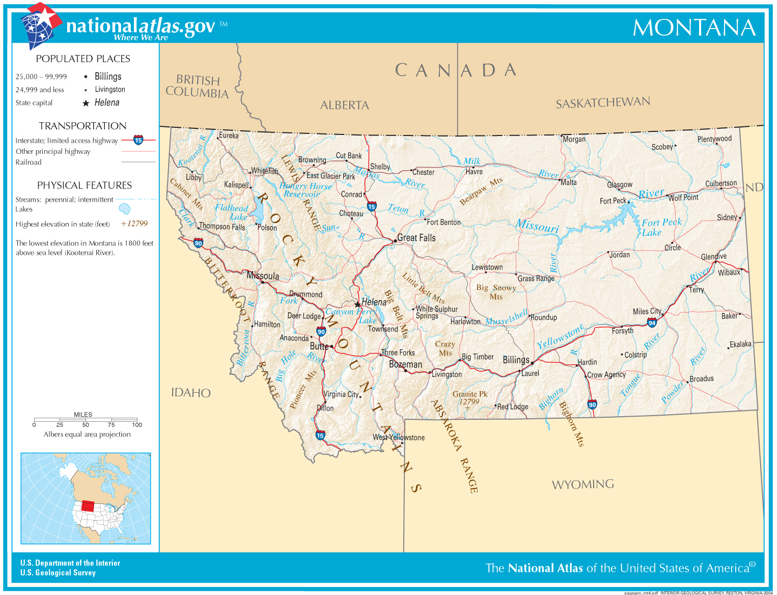
Montana is the fourth-largest U.S. state by area, covering 147,040 square miles (380,800 km2), making it larger than Japan. It is the largest landlocked state in the U.S. The state boasts an average elevation of 3,400 feet (1,036 m), with its highest point, Granite Peak, reaching 12,799 feet (3,901 m) in the Beartooth Mountains, and its lowest point along the Kootenai River at 1,804 feet (550 m). Montana shares a 760-mile (1,223 km) border with Canada, touching the provinces of British Columbia, Alberta, and Saskatchewan. Approximately 60% of Montana's land area lies east of the Continental Divide, comprising the Great Plains, while the remaining 40% is mountainous. The state contains over 3,000 named mountains, with 15 peaks exceeding 11,000 feet (3,353 m). Its water resources are substantial, with over 20,000 miles of rivers and streams and more than 3,000 lakes, including Flathead Lake, the largest freshwater lake west of the Mississippi River.
👥 Key People & Organizations
While no single individual is solely responsible for defining Montana's geography, figures like George Bird Grinnell were instrumental in advocating for the preservation of its natural wonders, leading to the establishment of Glacier National Park in 1910. The Bureau of Land Management and the National Park Service are key federal organizations managing vast tracts of Montana's public lands, including national forests and parks. State agencies like the Montana Department of Natural Resources and Conservation play a crucial role in managing water rights, forests, and conservation efforts. Indigenous tribes, such as the Blackfeet Nation and the Crow Nation, have deep historical and cultural ties to Montana's landscapes, with their ancestral territories encompassing significant geographical features and influencing land use practices for centuries. Geologists like J Harlen Bretz made significant contributions to understanding the state's geological history, particularly through his work on the Missoula Floods in the Columbia Basin, which originated in western Montana.
🌍 Cultural Impact & Influence
Montana's geography has profoundly shaped its culture and identity, fostering a spirit of independence and a deep connection to the natural world. The vast, open spaces and dramatic mountain vistas have inspired artists, writers, and filmmakers, contributing to the romanticized image of the American West. The state's geography has also dictated economic activities, from the ranching and agricultural industries that dominate the plains to the tourism and outdoor recreation sectors that thrive in the mountainous regions. The presence of significant natural resources, such as timber and minerals, has historically driven economic booms and busts, influencing boomtowns and the development of infrastructure like railroads. The stark contrast between the rugged mountains and the expansive plains has also created distinct regional cultures within the state, influencing everything from local dialects to political leanings. The iconic imagery of Montana, often featuring towering peaks, endless skies, and abundant wildlife, is directly derived from its unique geographical characteristics, solidifying its place in the American cultural consciousness.
⚡ Current State & Latest Developments
Current land use in Montana is a complex negotiation between conservation, resource extraction, and development. The state continues to grapple with the impacts of climate change, including increased wildfire frequency and intensity, altered precipitation patterns, and threats to its iconic snowpack, particularly in the Rocky Mountains. The management of public lands remains a critical issue, with ongoing debates surrounding grazing rights, logging, and recreational access. The energy sector, historically reliant on coal mining, is facing shifts as the nation moves towards renewable energy sources, prompting discussions about the future of resource-dependent communities. Water resource management is also a pressing concern, with increasing demands from agriculture, industry, and growing populations potentially straining supplies, especially during drought years. The state's burgeoning population, particularly in areas like Bozeman and Missoula, is also placing new pressures on its natural resources and infrastructure, leading to increased development and potential conflicts over land use.
🤔 Controversies & Debates
The management of Montana's vast public lands is a perennial source of controversy. Debates often center on the balance between conservation efforts, such as those championed by organizations like the Wilderness Society, and the economic interests of industries like logging, mining, and ranching. The designation of wilderness areas and the protection of endangered species, such as the grizzly bear, frequently pit environmental advocates against those who prioritize resource development or traditional land uses. Water rights, particularly in the arid eastern plains, are a constant point of contention, with historical water claims often clashing with modern needs. Furthermore, the increasing popularity of outdoor recreation, while economically beneficial, can lead to issues of overcrowding, habitat disruption, and conflicts between different user groups. The legacy of resource extraction, particularly coal mining, also sparks debate regarding reclamation efforts and the long-term environmental impacts on the state's geography and ecosystems.
🔮 Future Outlook & Predictions
The future of Montana's geography will be increasingly shaped by the impacts of climate change and evolving land-use policies. Projections indicate continued warming trends, leading to reduced snowpack, altered river flows, and a higher risk of severe wildfires, which could fundamentally change forest ecosystems and water availability. The state's energy future is likely to see a continued transition away from fossil fuels, with potential growth in renewable energy sectors like solar and wind power, though the siting of such projects can itself become a point of contention. Urbanization and population growth in gateway communities to national parks and mountain ranges will likely intensify pressures on infrastructure and natural resources, necessitating careful planning and land-use management. The ongoing efforts to balance conservation with economic development will remain a central theme, with debates over the role of public lands and the sustainable management of natural resources likely to persist and intensify as environmental and demographic pressures grow.
💡 Practical Applications
Montana's geography offers significant practical applications, primarily in the realms of natural resource management and outdoor recreation. The state's extensive river systems and mountainous terrain make it a prime location for hydroelectric power generation, with dams on the Missouri River providing a substantial portion of the state's energy. Its vast forests are a source of timber, supporting a significant logging industry, while its mineral-rich mountains continue to be exploited for coal, copper, and other valuable resources, though with increasing environmental scrutiny. The dramatic landscapes and abundant wildlife make Montana a premier destination for tourism and outdoor recreation, including hiking, fishing, hunting, skiing, and wildlife viewing, generating billions of dollars annually for the state's economy. Furthermore, its unique geological formations and ecosystems serve as invaluable natural laboratories for scientific research in fields ranging from geology and ecology to climate science, contributing to a broader understanding of Earth systems and environmental change.
Key Facts
- Year
- Ongoing
- Origin
- United States
- Category
- nature
- Type
- place
Frequently Asked Questions
What are the main geographical features of Montana?
Montana's geography is characterized by two primary features: the rugged Rocky Mountains in the west and the rolling Great Plains in the east. The Continental Divide runs through the western part of the state, acting as a major watershed and climatic boundary. Key features include numerous mountain ranges like the Beartooth and Absaroka, vast grasslands, and major river systems such as the Missouri River, which originates in the state. The presence of large lakes, including Flathead Lake, and ancient glacial formations further define its diverse topography.
How does Montana's geography influence its climate?
Montana's geography creates distinct climatic zones. The western mountainous regions experience cooler temperatures and heavy snowfall due to higher elevations and the influence of Pacific air masses, supporting alpine and subalpine climates. The eastern Great Plains are characterized by a semi-arid continental climate with greater temperature extremes – hot summers and cold winters – and lower precipitation. The Continental Divide significantly impacts precipitation patterns, often creating a rain shadow effect, with the western side receiving more moisture than the eastern plains.
What are the most significant natural resources found in Montana due to its geography?
Montana's geography has endowed it with abundant natural resources. The mountainous regions are rich in minerals, including coal, copper, gold, and silver, which have historically driven significant mining industries. The extensive forests in the western part of the state support a robust timber industry. The state's numerous rivers and lakes provide crucial water resources for agriculture, industry, and hydroelectric power generation, with the Missouri River system being particularly vital. The vast grasslands of the eastern plains are ideal for ranching and agriculture.
How has Montana's geography shaped its history and culture?
Montana's geography has profoundly shaped its history and culture. The rugged mountains provided refuge and hunting grounds for Indigenous peoples for millennia, and later attracted prospectors during the gold rushes, leading to boomtowns and conflicts. The vast plains facilitated ranching and agriculture, defining the state's economic backbone. The dramatic landscapes have fostered a culture of independence, self-reliance, and a deep appreciation for the outdoors, influencing its identity as 'Big Sky Country.' The challenges and opportunities presented by its geography have also shaped its settlement patterns, infrastructure development, and political landscape.
What are the primary challenges facing Montana's geography today?
Key challenges facing Montana's geography today include the impacts of climate change, such as increased wildfire frequency, altered snowpack, and changing river flows. Managing vast public lands involves ongoing debates over conservation versus resource extraction and recreation. Water resource management is critical, especially in drier eastern regions, due to competing demands from agriculture, industry, and growing populations. Population growth in certain areas also puts pressure on infrastructure and natural habitats, necessitating careful land-use planning to balance development with preservation.
How can one experience Montana's geography?
Experiencing Montana's geography involves engaging directly with its diverse landscapes. Visitors can explore the Rocky Mountains through hiking, camping, and skiing in areas like Glacier National Park or near Yellowstone National Park. The Great Plains offer opportunities for scenic drives, exploring ranches, and observing wildlife like pronghorn. Activities such as fishing in its numerous rivers, hunting in designated areas, or simply driving its scenic byways provide immersive experiences of Montana's vastness and natural beauty. Visiting state parks and national forests offers further access to its varied terrains.
What are the predictions for Montana's geography in the coming decades?
Predictions for Montana's geography suggest continued warming trends, leading to a significant reduction in snowpack and altered hydrological cycles, impacting water availability and ecosystems. Wildfire seasons are expected to become longer and more severe, potentially transforming forest landscapes. Population growth in desirable areas may increase development pressures, requiring adaptive land-use policies. The transition in energy production may also influence land use, with potential for increased renewable energy infrastructure. Conservation efforts will likely intensify as the state grapples with preserving its unique biodiversity and natural heritage amidst these changes.